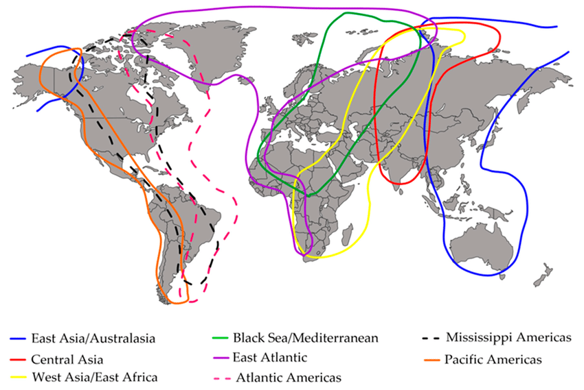
Have you ever wondered where birds go when the seasons change? Bird migration charts can unlock the secrets of these incredible journeys.
By understanding these charts, you’ll discover when and where different bird species travel, making your birdwatching more exciting and rewarding. Whether you’re a beginner or an expert, these charts give you the power to predict bird movements and connect with nature like never before.
Keep reading to explore how bird migration charts can transform your outdoor adventures.
Credit: www.futuremarketinsights.com
Basics Of Bird Migration
Bird migration is a regular trip for birds. They move between breeding and winter homes. Many birds fly thousands of miles each year.
We learn how they act from these trips. This data helps people protect them.
Why Birds Migrate
Birds move to find food. They also need safe spots for eggs. Cold weather pushes them away. They seek warmth.
-
Escape cold winters.
-
Find plenty of food.
-
Raise babies safely.
-
Stay away from hunters.
Common Migration Patterns
Birds follow set paths. Some fly north to south. Others go east to west.
| Pattern | Description |
| Latitudinal | North in spring. South in fall. |
| Altitudinal | Up and down mountains. |
| Longitudinal | East to west moves. |
| Loop Migration | Different paths each season. |
Factors Influencing Migration
Many things start the trip. Weather and food are key. Sunlight matters too.
-
Temperature shifts start seasons.
-
Food along the way.
-
Daily light hours.
-
Wind helps them fly.
-
Inborn skills guide them.
Avian Neurologists explain that birds have a “sixth sense” not usually shown on maps: “While charts show geographic paths, birds are actually following invisible magnetic lines. Many species have Magnetoreception, likely powered by ‘cryptochromes’ in their eyes—proteins that allow them to actually see the Earth’s magnetic field. This biological GPS ensures that even if a storm blows them off a charted route, they can recalibrate and find their way back to the specific rest stops identified on migration diagrams.”
Types Of Bird Migration Charts
Charts show bird paths across the map. Scientists use them to track birds. Many chart types exist today. Each one shows special details.
Seasonal Migration Maps
These maps show where birds go each season. Colors and dots mark their spots. They show population changes. You see the start and end.
-
Track birds by season.
-
Use colors for areas.
-
Mark nesting grounds.
Flight Path Diagrams
These show the exact lines birds follow. They connect dots to show routes. They reveal distances and paths. These maps show travel risks.
-
Connect travel points.
-
Show flight direction.
-
Identify rest stops.
Timing And Frequency Graphs
These graphs show when birds move. Bars show the busiest times. They help people plan bird trips. Researchers track moves over years.
-
Show travel months.
-
Mark peak times.
-
Track yearly changes.
How to Read Bird Migration Charts
Charts show bird travel times. Use them to know what to see. They use shapes and colors for data. Learning these parts helps a lot.
Interpreting Symbols And Colors
Charts use shapes for bird tasks. Shapes might mean rest or nesting. Colors show speed or path.
-
Circles show rest stops.
-
Arrows show path.
-
Red shows busy areas.
-
Blue shows rest spots.
Understanding Timeframes
Charts break the year into parts. Each part shows bird moves. Plan your trips using these times.
| Timeframe | Bird Activity |
| March – May | Move north. |
| June – August | Nesting season. |
| September – November | Move south. |
| December – February | Winter homes. |
Tracking Specific Species
Every bird has a unique path. Charts use names or codes. Follow a bird using these labels.
-
SP1: Northern Cardinal
-
SP2: American Robin
-
SP3: Canada Goose
Find these codes on your map.
Credit: birdcast.info
Tools For Tracking Bird Migration
Modern technology has revolutionized how we create and use Bird Migration Charts.
Various tools make it easier to follow birds during their long journeys across continents.
Satellite Tracking Technology
Small trackers send data to space. This shows exact paths.
-
Light tracking tools.
-
Live location data.
-
Long distance tracking.
-
Data for study.
Radar And Weather Monitoring
Radar finds bird groups in the sky. Weather data helps guess times.
| Tool | Use | Benefit |
| Weather Radar | Finds flocks. | Tracks paths. |
| Weather Satellites | Tracks climate. | Predicts moves. |
| Wind Maps | Shows wind. | Explains flight. |
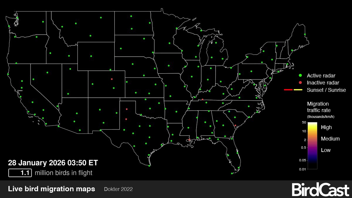
The Cornell Lab of Ornithology has set the gold standard for real-time data: “Authority Tip: If you want to see a migration chart in action, use BirdCast. It utilizes the US NEXRAD weather radar network to detect ‘biological targets’ (birds) in the atmosphere. Because most songbirds migrate at night to avoid predators and heat, BirdCast can predict exactly how many millions of birds will be flying over your specific zip code on any given night, providing a level of accuracy that static charts cannot match.”
Citizen Science And Apps
People report birds using apps. This builds huge maps. Public data helps scientists a lot.
-
Apps for watchers.
-
Share photos.
-
Check local data.
-
Get move updates.
Popular Bird Migration Routes
Routes show bird paths each year. They find food and safety. Each area has unique paths. Studying these protects birds.
North American Flyways
North America has four big paths. Birds fly these to breed. They follow rivers and coasts.
-
Pacific Flyway: West coast path.
-
Central Flyway: Great Plains route.
-
Mississippi Flyway: Follows the river.
-
Atlantic Flyway: East coast path.
European Migration Corridors
Europe has key paths too. Birds move north and south. Many cross the sea and Alps.
| Corridor | Start Region | End Region |
| East Atlantic | Scandinavia | West Africa |
| Black Sea | East Europe | North Africa |
| East Mediterranean | East Europe | Middle East |
| Central European | Central Europe | Southern Europe |
Asian Migration Paths
Asian routes cover huge areas. Birds cross deserts and peaks. These paths save many birds.
-
The Central Asian Flyway.
-
The East Asian-Australasian Flyway.
-
The West Asian Flyway.
Credit: www.album-online.com
Impact Of Climate On Migration
Bird migration is a natural event that depends on climate. Changes in the climate can affect where and when birds travel.
Understanding how climate impacts migration helps us protect birds and their habitats.
Changing Weather Patterns
Weather is changing fast now. Birds face storms or dry soil.
-
Early spring starts trips.
-
Late winter slows moves.
-
Bad weather confuses birds.
-
Temperature changes food.
Habitat Loss Effects
Heat and humans hurt habitats. Forests shrink every year.
| Habitat Type | Main Threat | Impact on Birds |
| Wetlands | Drying up. | No rest areas. |
| Forests | Cutting trees. | No food. |
| Grasslands | Building cities. | No nests. |
Adaptations In Migration Timing
Birds change dates for climate. This helps them find food. Some birds changed their dates.
-
Leave earlier in spring.
-
Arrive later in fall.
-
Take shorter trips.
Using Migration Charts For Conservation
Charts show where birds travel. Scientists use them for help. This data saves bird lives.
Conservation Ethicists provide a warning about sharing live data: “Trust involves protection. While migration charts are great for education, ‘real-time’ tracking of rare or endangered species is often slightly delayed or blurred by scientists. This prevents poachers or over-eager photographers from swamping a sensitive rest stop. When using public apps to report sightings, always be mindful of whether a bird is a ‘sensitive species’ to ensure its migration path remains a safe haven.”
Identifying Critical Habitats
Charts show rest and feed spots. These are key areas. Protect these spots for birds.
-
Rest sites.
-
Food rich areas.
-
Nesting grounds.
Planning Protected Areas
Charts help plan safe zones. These zones keep birds safe. This keeps bird counts high.
-
Map key paths.
-
Create bird parks.
-
Watch bird patterns.
Community Involvement In Conservation
Towns use charts to help. People report bird sightings. Support makes nature strong.
-
Start bird groups.
-
Teach in schools.
-
Keep yards safe.
Future Trends In Bird Migration Tracking
Bird migration tracking is changing fast. New tools and methods help scientists learn more about birds.
These advances improve how we follow bird routes and understand their behavior during migration.
Advances In Tracking Technology
Devices are now small and light. They track small birds safely. Solar tags send live data.
-
Small GPS tools.
-
Solar power tags.
-
Better data links.
-
New weather sensors.
Big Data And Ai Applications
Big data stores bird facts. AI looks at data fast. AI guesses where birds go.
-
Store tracking facts.
-
Find trends fast.
-
Guess climate shifts.
-
Quick data study.
Global Collaboration Efforts
Scientists share facts every day. This tracks birds across nations. Teamwork helps birds survive.
-
Share data globally.
-
Use one platform.
-
Team up for birds.
-
Make data match.
Frequently Asked Questions
What are bird migration charts for?
They track bird moves. Scientists use them to find paths. They help protect nature.
How do they help birdwatchers?
They show the best times for birds. You can plan your trips better. Identifying birds becomes easy.
Can they predict arrival times?
Yes. They use past facts to guess dates. Weather facts help too. This helps with research.
Where can I find these charts?
Check nature groups online. Government sites have them too. Apps provide live maps.
Conclusion
Bird Migration Charts open a fascinating window into the journeys of birds across continents. They help birdwatchers, researchers, and conservationists understand where birds travel, when they move, and which habitats are critical for their survival. By studying these charts, we gain insight into migration patterns, species behavior, and the effects of climate and habitat changes. These tools not only enhance birdwatching experiences but also guide efforts to protect birds and their environments. Whether you’re observing from your backyard or exploring remote flyways, migration charts connect you to the incredible, intricate world of avian travelers.